Monday, October 26, 2009

Talk on "The Geospatial Revolution" in Minnesota

Here is a video of my recent keynote talk at the Minnesota GIS/LIS conference in Duluth, which was an excellent event. There were about 500 people there, which is great in the current economic climate. It was mainly a "traditional GIS" audience, and I got a lot of good feedback on the talk which was nice.

I talk about current trends in the industry in three main areas: moving to the mainstream (at last!); a real time, multimedia view of the world; and crowdsourcing. There's a lot of the same material that I presented in my talk with the same title at AGI GeoCommunity (which doesn't have an online video), but this one also has additional content (~50 minutes versus 30 minutes).

Click through to vimeo for a larger video, and if you click on "HD" you will get the full high definition version!! I used a different approach to produce this video compared to previous presentation videos, using a separate camera and a different layout for combining the slides and video. I like the way this came out - I'll do a separate blog post soon with some tips on how to video presentations, I think.

The Geospatial Revolution (Minnesota) from Peter Batty on Vimeo.

You can also view the slides here:

Sunday, October 25, 2009

Google Maps data correction - a strange semi-update

I reported previously that I found that Google Maps was missing Central City Parkway after their change in street data provider (they are now providing their own street data rather than using Tele Atlas). I reported the error to Google and said I would report back here when it was fixed - Google is aiming to fix errors within 30 days. This evening Tom Churchill commented on my previous post to say that Central City Parkway was now present on the map - I thought it was odd that it had been fixed but I hadn't received an email to let me know, as promised. I reported the problem 17 days ago and received confirmation that it was an error and they would work on it 13 days ago.

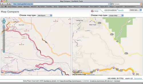
Anyway, when I went to check out the updated map, this is what I saw (Google is on the right, OpenStreetMap on the left):

Partial update to Central City Parkway in Google Maps

This compares to the previous comparison screenshot I did, which looks like this:

Central City Parkway missing from Google Maps

So there is now a road on the map that follows the path of Central City Parkway, when there wasn't before. But it's drawn as a minor road when it should be a major highway (a "divided highway" or "dual carriageway" depending on where you come from!), and it has no name shown on the map. And when I try to get Google Maps to route along it, it stubbornly refuses to do so, even if I try to drag the route to force it along there (when dragging, it doesn't allow me to drop on this street):

Central City Parkway not routing yet in Google Maps

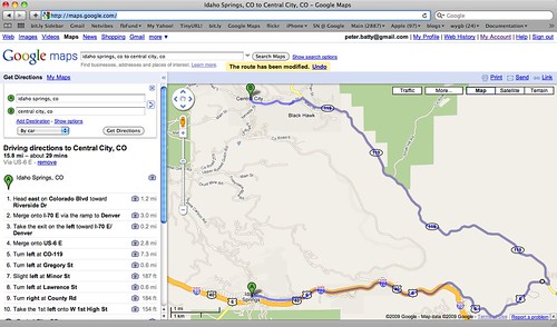
So anyway, we seem to have a curious semi-update - there's a new geometry there that wasn't there previously, along the route of Central City Parkway, but with no name, the wrong road classification, and you can't route along it. Seems odd that a partial update like this should find its way into the live database ... I guess the process is still slightly "beta" :O !! Will keep an eye on it and report back on further progress!

Monday, October 19, 2009

Location Based Services in 2014 - Part 1

The AGI in the UK is currently carrying out a "Foresight Study" to look at where the geospatial industry will be in five years' time. They have asked several dozen people to contribute short reports on different topics, and I was asked to write about Location Based Services. I thought I would publish the current working draft here, and I encourage you to contribute comments and suggestions that I can work into the final version. This is Part 1 of 2.

As an aside, I think that predicting 5 years out for Location Based Services is not unreasonable right now - we have had several significant breakthroughs in the past year or two, and so can make some fairly safe predictions based on widespread adoption of those. Timing makes a lot of difference - 5 years ago we had no Google Earth and no Google Maps (both launched in 2005), so any 5 year geospatial industry predictions back then would have been way off! Of course there will still be plenty of innovations that we don't anticipate too!


Scope
For the purposes of this discussion, a location based service is defined as a software-based service where a key element of that service is the current location of the user, derived using location sensing technology. We also consider applications that are based on data derived from users of location based services (such as real time traffic flow information); applications based on sensing the location not of users, but other objects such as vehicles or equipment; and some applications where the location of the user is not derived from sensors (for example applications based on anticipated future location).

Current Position
Location Based Services have been widely touted as “the next big thing” since the late 1990s, just before the dot com bubble burst. We have (finally) seen significant progress in the past couple of the years, with the iPhone in particular bringing location based services to a mainstream audience for the first time. A key limitation with the iPhone currently is that applications cannot run in the background, which rules out an important subset of location based services, those that carry out notifications or other actions proactively based on your current location. Battery life is still a challenge for continuously logging location of a phone, as GPS is relatively power hungry.

Most new phones now have location capabilities. We are also starting to see new capabilities that are very relevant to location based services, including compasses built in to smart phones, and augmented reality applications that combine location awareness, compass and built in camera. These capabilities provide new and compelling user interface capabilities for location based applications.

Anticipated Changes
Location tracking will be pervasive in 2014 – all mobile phones will have location tracking. Location based applications will be able to run in the background, overcoming a key current limitation (this will require improvements in battery technology). Built in compass, camera and augmented reality capabilities will also be on most if not all phones (as a baseline, consider that the proportion of phones with cameras exceeded 70% globally in 2008, with 75% anticipated in 2009).

The great majority of phones will be “smart phones” with capabilities exceeding today’s iPhones, including high quality graphics, touch screens, and the ability to run sophisticated applications (a basic iPhone costs $99 today, and in 5 years we will have had just over 3 iterations of Moore’s Law, so price performance will have improved by a factor of roughly 10).

Crowdsourcing and widespread use of sensors means that a wide variety of good quality and extremely current geospatial data will be available for free, including:
  • Road data, with relevant information for routing, including real time traffic information
  • Footpaths and cycle paths, with relevant information for routing
  • Points of interest such as restaurants, shops, petrol stations, ATMs, etc, plus relevant real time information such as gas prices
Additional types of location sensing technology will be common, including the following:
  • Proximity sensors, for example RFID or Bluetooth, which can detect when two devices are within a short distance of each other. One current example is a smart key, which will cause a car door to open when it is within a short distance. Another might be a Bluetooth device in a museum that displays relevant information, or plays relevant audio, on a smart phone when it is close by.
  • Continuous local sensors, such as WiFi or ultrawideband (UWB). UWB has a much higher degree of accuracy (~30cm) compared to WiFi (meters or tens of meters depending on number of sensors and environment). High precision sensors enable a variety of indoor location based applications that are not possible with GPS.
  • Very inexpensive passive RFID sensors (will be a few cents in this timeframe), which will be used to track huge numbers of inexpensive assets (at discrete points where they can be scanned, for example the entrance to warehouses or stores).
Usage of social networking applications will be highly pervasive. Unlike today, users will be able to maintain one common set of information about their networks of friends and business associates, and share this among multiple applications. This will be important for location related applications, for specifying what aspects of a person’s location information may be shared with whom.

High speed wireless communications networks will be pervasive in most parts of the world. It also seems reasonable to assume that the majority of newer vehicles will include a location tracking device and wireless communications by 2014.

Update: Part 2 discusses the impact of these changes on the geospatial industry, look at various application scenarios, and summarize five key points.

Thursday, October 15, 2009

"Georant" on free geodata, Ordnance Survey and USGS

I'm a little behind on this - you may have already caught this video of me doing a "georant" at AGI GeoCommunity via Jonathan (who kindly said it was "rather funny") or GeoCommunityLive (who said that the audience were in hysterics, and "at the same time Peter had some serious points to make about the potential pitfalls of the 'free' model").

I basically discuss the fact that many people massively oversimplify the arguments for and against free government geodata. The georant format was a fun one, the idea being to have short entertaining talks accompanied (or fueled?!) by beer, with an Ignite style format (15 slides which automatically advance every 20 seconds, for a total of 5 minutes). I recommend it to other conference organizers!


And here are the slides - you get a glimpse of some in the video and not others, so feel free to follow along by advancing these. For the benefit of those not from the UK, slide 2 features Vanessa Lawrence, Director General and Chief Executive of the Ordnance Survey, and the appearance of that slide was what prompted the burst of laughter that you hear about 20 seconds in!
And finally perhaps I should also explain that the conference party had a "dress code" of "black and white", which was the reason for the cowboy outfit ... though given the amount of coverage my cowboy hat generated, I may have to use it again for future presentations :) !!

Wednesday, October 14, 2009

A black hole isn't "evil", but ...

I loved this quote from Paul Ramsey, commenting on Paul Bisset's blog post about the "Google data earthquake":
Right, a black hole isn’t “evil”, but that doesn’t change the fact that it massively distorts the shape of space-time everywhere it goes, which can be a bummer for any object in its immediate neighbourhood.
That summarizes rather nicely concerns I've expressed in recent posts.

Tuesday, October 13, 2009

Speaking in Minnesota next week

Just a quick post to say that I will be doing the opening keynote talk next week (Thursday October 22nd) at the 19th annual Minnesota GIS/LIS conference, in Duluth. It should be a fun and interesting event, so if you're up in that part of the world I encourage you to stop by!

More on the "Google data earthquake"

Following on from my previous post about Google shaking up the geospatial data industry, Steve Coast invited me and James Fee to join him for a discussion on the topic. James' blog post on the topic has 138 comments at the time of writing, which is a good indication of the interest in this change! You can listen to the podcast on the "Google data earthquake" here.

One topic I talk about in the call which I didn't cover in my previous post is where the Google street data comes from (they haven't said anything about this). To me it looks like a mixture of data they have captured from their StreetView cars, which seems to be good quality, and then probably TIGER data, which is much lower quality, where their cars haven't driven. Quite a few people have reported finding errors in street data that weren't there previously since the change. I found that Central City Parkway was missing from the map entirely, which is a pretty major highway that was completed in 2004. You can see this below, with OpenStreetMap on the left, and Google Maps on the right (screen shot using GeoFabrik's nice map compare tool):

Central City Parkway missing from Google Maps

I've reported the error to Google, so it will be interesting to see how quickly it gets fixed - and in general, how quickly they are able to fix up the apparently lower quality data in areas they haven't driven yet (though this assessment is not based on anything scientific).

Wednesday, October 7, 2009

Google shakes up the geospatial data industry

Well, the big news of the day is that Google has dumped Tele Atlas as the main data provider for Google Maps in the US, and is providing its own map data from a variety of sources (presumably also including its own Streetview teams). They've also added the ability to point out errors in the map, another addition to the crowdsourcing techniques they've been using. The announcement has caused a flurry of discussion of course. James raises questions about various aspects of the data (especially parcels). Steve speculates that the same thing will happen in Europe and that the beneficiary there will probably be AND.

The new Google data certainly adds details in some places, from a quick random sampling - for example check out Commons Park in downtown Denver using the nice GeoFabrik Map Compare tool. None of those paths were there previously in Google. Still not quite as good as OpenStreetMap in this case though :).

This does dramatically reshape the geospatial data industry though. Previously there were two commercial providers with a detailed routable database of roads in the US, NAVTEQ (owned by Nokia) and Tele Atlas (owned by TomTom), now at a stroke there is a third in Google. OpenStreetMap is a fourth provider of course, not quite up with the other three in terms of coverage and routing quality in the US yet, but getting there very quickly.

This raises lots of interesting questions:
  • Will Google sell its data to providers of third party navigation systems and compete with Tele Atlas and NAVTEQ? Or indeed will they sell/license it to others who could use it (users of GIS, etc)?
  • Will Google Maps on the iPhone (and other mobile devices) get real time turn by turn directions? This was previously prohibited by licensing terms from Tele Atlas and NAVTEQ. Existing real time navigation systems using data from these two providers generally cost in the region of $100. Will Google add this to the free maps offering? Or sell a version that does real time turn by turn directions?
  • Will Google contribute any of this data to open data initiatives like OpenStreetMap? Or make it available to USGS for the US National Map? In the past they have cited licensing constraints from their data providers as a reason for not being more open with their geospatial data, that reason largely goes away now (though we don't know all the new data providers and their terms). I'm not holding my breath on this one, but we can hope!
  • Will this negatively or positively impact OpenStreetMap? Previously in areas with active communities, OpenStreetMap had significantly more detail, and more current data, than Google - this appears to move Google forward in that regard. But will Google taking another step towards total world domination encourage more people to want an open alternative?
So anyway, definitely a very interesting development for the geospatial data industry (albeit one that has been on the cards for a little while). It will take a little while to understand the full implications. I'm sure Tele Atlas is glad they are no longer an independent company, I wouldn't like to have seen how their stock price would have dropped today otherwise :O !!

Update: some more discussion and a link to a podcast on this topic featuring Steve Coast, James Fee and me in this follow up post.

Jack Dangermond on GeoDesign

In my previous post on GeoDesign (and Shakespeare), I was curious about why (it seemed to me) ESRI was positioning design in GIS as something new. Their position was clarified by no less an authority than Jack Dangermond in the comments - I thought that Jack's thoughts deserved a new post of their own rather than being hidden away, so here they are ...
Thanks for noticing our efforts in GeoDesign and yes, you are certainly correct; the consideration of geographic factors as part of design is not new. Your personal efforts to develop engineering design tools while you were at Smallworld was not only good work but built on a long history of human thought and innovation in this area.

I suppose everyone sees design and design methodology differently as it relates to their background and experience.

In my case, I was first introduced to the efforts of Phillip Lewis and Ian McHarg in the 1960s. They both developed manual techniques for landscape planning involving plastic overlay maps. They used these overlays to describe constraints and opportunities presented by geography. These maps were typically used as the basis for "designing" open space and other land use plans.

Later, Carl Steinitz, a professor at Harvard, laid out a computer-based methodology using early GIS tools. His methods pioneered both computer suitability analysis and environmental impact modeling.

Today my colleagues and I are advancing these techniques by integrating a series of new tools and methods into our GIS software. We are also promoting the ideas that we need to more directly integrate geographic information into many forms of spatial design and decision making. While these techniques are certainly relevant for land use and natural resource planning, they also have enormous value for any type of geographic site selection, corridor planning, or area-wide planning efforts. In fact, they can be a benefit in most human activities which change geography.

The fundamental technology we have developed is not profound. It involves sketching on top of smart analytic maps and getting fast feedback. This technology, however, has to be complemented with a methodology involving the integration of geographic science and other layers with an interactive design process which allows users to sketch and get rapid feedback on the consequences of their alternative designs.

Our technology is being deployed in both desktop and server platforms. We believe that the Web Server technology is particularly interesting because when deployed on the Web, it promises to lead to a whole new way of collaborative and community based planning. Ultimately this platform promises to also provide very broad based access to users of all types. Who knows, a whole new world of "geodesigners" may emerge like neogeographers – people who participate in volunteer efforts to design a more sustainable world.

These ideas are not new. We are hoping our technical efforts and promotion of these ideas will lead to more integration of geographic thinking into all that we do; specifically that people who are responsible for changing our geography are fully aware of the consequences and implications of the changes as they are made.

This January we are having our first GeoDesign symposium in California. It is being co-sponsored by the University of California, the University of Redlands, and ESRI. There will be many academic and design firms participating. Presentations will be made on theory, technology and methodology associated with GeoDesign. We welcome participation by those interested in these ideas (see geodesignsummit.com)